"RTK gives centimetre accuracy" is true only in one specific state, and drones spend plenty of flights in the other two without anyone noticing. If you're relying on RTK for mapping, precision navigation or anything a client signs off, understanding the solution states is the difference between data you can defend and data you can't. This builds on RTK vs GNSS vs PPK.
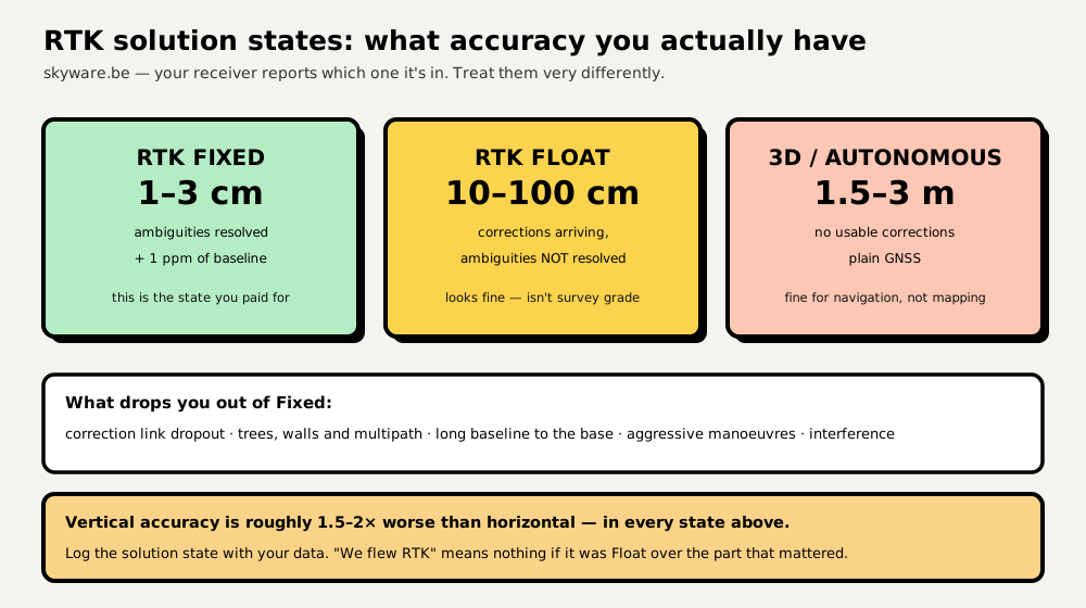
RTK Fixed = 1–3 cm horizontally (+1 ppm of baseline). RTK Float = roughly 10–100 cm. Autonomous/3D (no usable corrections) = 1.5–3 m. Vertical accuracy is about 1.5–2× worse than horizontal in every state. Only a Fixed solution delivers what "centimetre-level RTK" advertises.
Why there are three states at all
RTK works by measuring the carrier phase of the satellite signal — counting radio wavelengths (~19 cm each) rather than just decoding timing. That's what makes centimetres possible. The catch is that the receiver must work out the whole number of wavelengths between it and each satellite: the integer ambiguity. Resolving those integers is what "getting a fix" means.
- Fixed — ambiguities resolved. Centimetre accuracy. What you want.
- Float — corrections are arriving and being used, but the integers aren't resolved yet, so the solution is a best estimate. Decimetres.
- Autonomous / 3D — no usable corrections. Plain GNSS, metres.
A receiver can transition between these several times in one flight, and it usually does so quietly.
The numbers, in context
| State | Horizontal | Vertical | Good enough for |
|---|---|---|---|
| RTK Fixed | 1–3 cm + 1 ppm | ~2–6 cm | Survey, stakeout, precision landing, repeatable lines |
| RTK Float | ~10–100 cm | ~20–150 cm | Better-than-nothing navigation; not survey |
| Autonomous GNSS | 1.5–3 m | 3–6 m | Waypoint navigation, return-to-home |
The 1 ppm term means accuracy degrades ~1 mm per kilometre from the base — negligible over a site, real over a long corridor (see base stations & NTRIP). And vertical is always worse, because satellites are only ever above you: the geometry that fixes horizontal position beautifully is weak in the vertical axis. Anyone quoting one number for "accuracy" is quoting the horizontal one.
What knocks you out of Fixed
- Correction dropout — the radio or NTRIP stream stalls. The most common cause by far.
- Sky obstruction and multipath — trees, buildings, canyons, working close to steel structures.
- Long baseline — too far from the base for the shared-error assumption to hold.
- Antenna problems — bad siting, no ground plane, or noise from video transmitters and USB3 devices.
- Interference or jamming — increasingly common near infrastructure (jamming & spoofing).
Re-acquiring a fix after an outage takes seconds to minutes depending on conditions — which is exactly why a drone can fly a whole survey line in Float without the pilot realising.
Every serious workflow records the solution state per measurement — per photo, per scan line, per waypoint. "We flew RTK" is not a quality claim; "98% of exposures were RTK Fixed, the remaining 2% flagged and excluded" is. This is also why PPK is popular for mapping: post-processing lets you see, and often repair, exactly where the solution degraded.
Related things people mean by "RTK accuracy"
- Relative vs absolute. A self-surveyed base gives tight relative accuracy (internally consistent, repeatable) but the whole dataset can sit metres off in absolute terms. Tie to a known point or network if the job needs true coordinates.
- RTK heading. Two antennas on one aircraft give heading from GNSS instead of the magnetometer — invaluable near steel where compasses lie (see the sensor suite).
- Accuracy ≠ product accuracy. Centimetre camera positions don't guarantee a centimetre map: image quality, overlap and processing all add error. Verify with independent checkpoints, as covered in RTK drone surveying.
Frequently asked questions
How accurate is RTK GPS?
With a Fixed RTK solution, typically 1–3 cm horizontally plus about 1 ppm of the distance to the base station (1 mm per km). Vertical accuracy is roughly 1.5–2× worse than horizontal. Without a Fixed solution those numbers do not apply — Float is decimetre-level and autonomous GNSS is 1.5–3 m.
What is the difference between RTK Fix and Float?
In a Fixed solution the receiver has resolved the carrier-phase ambiguities — the whole number of radio wavelengths to each satellite — giving centimetre accuracy. In Float it is still receiving corrections but has not resolved them, so accuracy falls to roughly 10–100 cm. Float looks healthy on screen but is not survey grade.
What does RTK mode mean on a drone?
It means the drone is using a correction stream from a base station or network to improve its GNSS position. The important detail is which solution state it achieves: only RTK Fixed delivers the centimetre accuracy people buy RTK for, and drones report that state in their telemetry and logs.
Why is my RTK not getting a fix?
The usual causes are an interrupted correction link, poor sky visibility or multipath near trees and buildings, too long a baseline to the base station, a badly sited or noise-affected antenna, or interference. Check the correction stream is arriving first, then the antenna's view of the sky.