"GNSS", "RTK" and "PPK" get thrown around as if they're competing products. They're not — they're three layers of the same thing, and understanding how they stack is the fastest way to stop being confused by drone spec sheets. This guide is the plain-language version; the deeper engineering lives in the RTK & GNSS for drones pillar.
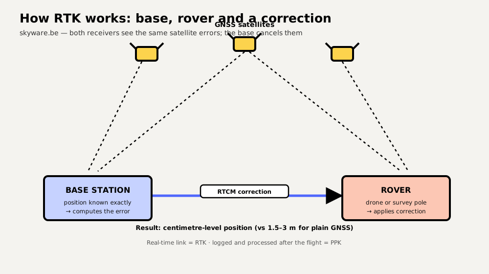
GNSS: the foundation
GNSS (Global Navigation Satellite System) is the umbrella term for the satellite constellations your receiver listens to — GPS (US), Galileo (EU), GLONASS (Russia) and BeiDou (China). A plain GNSS receiver works out its position from satellite signal timing and lands within about 1.5–3 metres. That's fine for "return to home", useless for landing on a pad or flying repeatable survey lines. Everything below is about closing that gap. (People often say "GPS" when they mean GNSS; GPS is just one constellation.)
Why plain GNSS stops at metres
The signals arrive slightly corrupted — atmospheric delay, satellite clock and orbit errors, reflections. Crucially, most of those errors are almost identical for two receivers a few kilometres apart. That shared-error fact is the entire trick behind both RTK and PPK.
RTK: correct it in real time
RTK (Real-Time Kinematic) puts a second receiver — a base station — at a precisely known location. Because the base knows exactly where it is, it can measure how wrong the satellites currently are and broadcast a correction to the drone (the "rover") over a radio or internet link. The rover applies it and resolves position to 1–3 cm, live, in flight. The catch: it needs that correction link working continuously, and it reports its state honestly — Fixed (centimetres), Float (decimetres) or plain 3D (metres), which your autonomy must treat differently.
PPK: correct it afterwards
PPK (Post-Processed Kinematic) uses the same physics but skips the live link. The drone and the base each log raw satellite data; after landing you combine the two logs in software to compute a precise track. You lose real-time precision (the aircraft flew on ordinary GNSS), but you gain robustness — there's no correction link to drop out mid-flight, and you can even use a base station you didn't own by downloading its public logs later. For mapping, where only the photo positions need to be accurate, PPK is often the preferred, lower-risk choice.
The comparison, at a glance
| Plain GNSS | RTK | PPK | |
|---|---|---|---|
| Accuracy | 1.5–3 m | 1–3 cm (when Fixed) | 1–3 cm (post-processed) |
| When you get it | Live | Live, in flight | After landing |
| Needs live correction link | No | Yes | No |
| Survives link dropouts | n/a | Degrades to Float/3D | Yes (robust) |
| Best for | Navigation, RTH | Precision flight, real-time work | Mapping & survey geotagging |
A one-line rule for choosing
Do you need the precise position during the flight? If yes — precision landing, real-time navigation, guiding an operation — you need RTK, and a solid correction link. If you only need accurate positions after the flight — geotagging survey imagery — PPK is simpler and more robust. And if metres are fine, plain GNSS already does that for free. You don't "pick GNSS vs RTK"; you decide whether to add real-time or post-processed correction on top of GNSS.
Two things people get wrong
- "RTK replaces GPS." No — RTK is GNSS with corrections. Same satellites, better maths.
- "RTK is immune to interference." No. RTK improves accuracy but is just as vulnerable to jamming and spoofing as any GNSS — corrections can't help a receiver that's being lied to or drowned out.
Ready for the hardware and workflow? Continue with RTK base stations & NTRIP and RTK drone surveying, or the full RTK & GNSS engineering guide.
Frequently asked questions
What is the difference between GNSS and RTK?
GNSS is the satellite positioning itself (GPS, Galileo, GLONASS, BeiDou), accurate to roughly 1.5–3 metres on its own. RTK (Real-Time Kinematic) is a technique layered on top of GNSS that uses corrections from a base station to reach centimetre accuracy in real time. So RTK is not an alternative to GNSS — it's GNSS made ~100× more precise.
What does RTK mean on a drone?
It means the drone carries a GNSS receiver capable of applying real-time corrections from a base station or network, giving it centimetre-level position instead of the usual few metres. That enables precise mapping, repeatable flight lines and accurate geotagging without ground control points.
Should I use RTK or PPK for drone mapping?
Use RTK when the aircraft needs a precise position in flight (precision navigation, real-time work) and you have a reliable correction link. Use PPK when you only need accurate photo positions afterwards — it records raw data and computes positions post-flight, so it's more robust to link dropouts. Many mapping workflows prefer PPK for exactly that reason.